


OVS Founders Map Details Century-Old Jewish Atlanta
The anticipated and recently released Or VeShalom mapping project details Southside Atlanta Jews and their homes from more than 100 years ago.
Rachel is a reporter/contributor for the AJT and graduated from the University of Central Florida in Orlando. After post graduate work at Columbia University, she teaches writing at Georgia State and hosts/produces cable programming. She can currently be seen on Atlanta Interfaith Broadcasters.

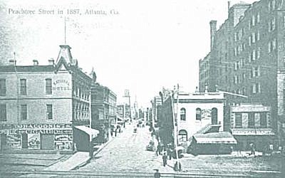
The project began 20 years ago when Congregation Or VeShalom member Dan Maslia’s son handed him a map of Jewish Atlanta from almost a century ago. Houses and structures of the time were delineated, and the map detailed the area from Memorial Drive south to Bass Street, then east to Capitol Avenue before heading north. It was a 20-square-block radius of the history of where Jews had lived in the 1900s, and it even included Turner Field. As a native Atlantan, Maslia’s interest was peaked, and his research began. Now, two decades later, the Or VeShalom Founders Map Project is available for anyone who would like to see it.

This map of Atlanta’s south side represents the area where the majority of Jews lived in the early part of the 20th century. Ashkenazim were the first to arrive, but more Sephardim came to the area in 1906. When Maslia began researching the people who lived in that area, he knew that quite a few Jewish families were there already. It wasn’t until he did further investigation that he realized how big this project could possibly be. “My wife and I decided to visit the Breman Museum and the Atlanta History Center, and we started to find the directories with all the streets and houses in Atlanta,” Maslia said. “We started with the year 1918, and we looked for books and directories from that area. We didn’t know what we were really doing yet, so we took photos of each page we thought might be useful with our cell phones. When we were done, we had about 500 to 600 pages.”
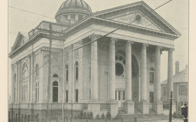
Having been born in Atlanta and living here for much of his life, Maslia was familiar with many of the names and families found in his research, particularly those of congregants of OVS. He began to place those names and streets of OVS members from the years of 1918 to 1941 on a spreadsheet and plotted where each family or person lived on each street. He was able to see that his father had moved four times within the area and locate each home in which he lived. The research yielded about 350 Sephardic homes and propelled Maslia to continue his investigation. He eventually also developed an alphabetical listing of everyone who lived in those houses and compared much of his research to the 1934 census of OVS congregants. Many of the buildings go back much further though. The project went as far back as to profile the Hebrew Benevolent Congregation, the predecessor of The Temple, between Pryor and Richardson streets and the Hebrew Orphans Home that spanned the entire block of Washington Street. Also visible is The Standard Club from 1905 on Washington Street, originally the mansion of William C. Sanders. It moved in the 80s to Johns Creek.
The map project has elicited the attention of people not only from OVS, but from the larger Jewish community and Atlanta. Many of the families profiled and their relatives, including Maslia and his family, are still living in the area today. “People have been contacting me,” Maslia said. “People who lived in that area have been interested to see where their friends or their friends’ families lived. Many of my Ashkenazi friends called me and recognized some or their businesses or their relatives’ businesses. It’s a nice feeling.”
The Atlanta History Center, the history department of Georgia State University, and the William Breman Jewish Heritage Museum have copies of the lists, and Maslia has published his collection. In conjunction with the OVS history committee, he has made the map with all of its findings available for purchase. An accompanying booklet containing the exact addresses of more than 150 OVS members who arrived in Atlanta beginning in 1906 is also available.
Because of the interest and success of his first publication, Maslia is now working on his second. He’s identifying businesses within that 20-block radius, and at 425 businesses so far, he’s close to completing the research. The project has taken the better part of two years, but will be finished within five or six weeks and be available shortly after that.

“We did this primarily for the benefit of the people who lived there, but also for their children and their grandchildren to see where they lived,” Maslia said. “There are so many synagogues. Starting from 1918 to 1941, this is where we all were. It’s a glimpse for all those people into another era. It’s our history as Jews.
comments